Category:Maps
Jump to navigation
Jump to search
visual representation of a concept space; symbolic depiction emphasizing relationships between elements of some space, such as objects, regions, or themes _ESA23162625.png) 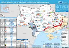 | |||||
| Upload media | |||||
| Pronunciation audio | |||||
|---|---|---|---|---|---|
| Instance of | |||||
| Subclass of |
| ||||
| Part of |
| ||||
| Different from | |||||
| |||||
- (en) Map
- (an) Mapa
- (ar) خريطة
- (ast) Mapa
- (bg) Карта
- (bn) মানচিত্র
- (bs) Karta
- (ca) Plànol
- (cs) Mapa
- (cy) Map
- (da) Kort (geografi)
- (de) Karte (Kartografie)
- (eo) Mapo
- (es) Mapa
- (et) Kaart (kartograafia)
- (fa) نقشه
- (fi) Kartta
- (fr) Carte géographique
- (gan) 地圖
- (gl) Mapa
- (he) מפה
- (hi) मानचित्र
- (hr) Karta
- (hu) Térkép
- (id) Peta
- (is) Kort
- (it) Mappa
- (ja) 地図
- (ka) გეოგრაფიული რუკა
- (ko) 지도
- (la) Tabula geographica
- (lb) Landkaart
- (lt) Žemėlapis
- (ml) ഭൂപടം
- (ms) Peta
- (nl) Kaart (cartografie)
- (nn) Kart
- (no) Kart
- (oc) Mapa
- (pl) Mapa
- (pt) Mapa
- (ro) Hartă
- (ru) Географическая карта
- (sa) Хаарта
- (sco) Cairt
- (si) ple:Map
- (sk) Mapa
- (sl) Zemljevid
- (sq) Harta
- (sr) Карта (мапа)
- (su) Atlas
- (sv) Karta
- (sw) Ramani
- (ta) நிலப்படம்
- (tg) Харита
- (th) แผนที่
- (tl) Mapa
- (tr) Harita
- (uk) Географічна карта
- (vi) Bản đồ
- (yi) מאפע
- (zh) 地图
- (zh-classical) 地圖
- (zh-yue) 地圖
Before changing or adding maps, please read the brief guideline on the organizational schema About this Category developed during an eight month effort by a working group in 2007–2008.
- See also maps needing categories in Category:Unidentified maps
- See also these related categories: (These categories may contain more maps. Please categorize them in map categories.)
- Category:Cartography – for map symbols, projections, etc.
- Category:Demography
- Category:Geography
- Category:Aerial photographs
- Category:Satellite pictures
- Category:Astronomical maps – maps and star charts
- Category:Cartographic reliefs for models of landscape profiles
Resources:
Subcategories
This category has the following 24 subcategories, out of 24 total.
!
*
?
A
M
P
W
Media in category "Maps"
The following 21 files are in this category, out of 21 total.
 Ameerega trivittata 2.png 459 × 278; 211 KB
 An old map of Zeila featuring the Somali Gadabuursi Dir clan2.jpg 1,822 × 1,350; 638 KB
.svg/120px-AZ01_2022_US_House_(Wiki).svg.png) AZ01 2022 US House (Wiki).svg 2,391 × 1,593; 352 KB
AZ01 2022 US House (Wiki).svg 2,391 × 1,593; 352 KB
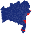 Bahia 47.png 1,132 × 1,198; 344 KB
 Baldy Town Map 1921.jpg 1,166 × 860; 249 KB
 British Empire Flag Map 2.png 6,000 × 4,103; 807 KB
 Glasgow agreement map 1.3.svg 2,754 × 1,398; 1.17 MB
 Glasgow agreement wiki map 1.2.svg 2,580 × 1,310; 1.17 MB
 Hetény and its surroundings at the middle of the 19th century.png 3,658 × 2,842; 21.66 MB
 IAEA Technical Co-operation Agreement Region.svg 2,754 × 1,398; 1.05 MB
 Kurdish states.jpg 2,798 × 2,100; 404 KB
.jpg/120px-Map_of_Brisbane_Town_by_Robert_Dixon_24_March_1840_(7173003438).jpg) Map of Brisbane Town by Robert Dixon 24 March 1840 (7173003438).jpg 3,000 × 2,267; 887 KB
Map of Brisbane Town by Robert Dixon 24 March 1840 (7173003438).jpg 3,000 × 2,267; 887 KB
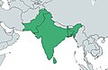 Map of Pakistan, Bangladesh, India and Sri Lanka.jpg 1,323 × 862; 312 KB
 Mapa da Rota de Peregrinação Caminho da Luz.jpg 420 × 420; 53 KB
 Mapa Porangatu.png 472 × 528; 4 KB
 Ocorrências conhecidas de Ameerdida trivittata.png 602 × 330; 275 KB
 Pará 1965.png 1,163 × 1,118; 180 KB
 Teheran synagogues map.jpg 2,184 × 2,159; 1.72 MB
 Ukraine map 2023 2.png 2,550 × 3,600; 447 KB
 Usa location map.svg 1,181 × 731; 2.03 MB


.svg)


.jpg)


_-_Second_military_survey_of_the_Habsburg_Empire.png)


