File:05june-dow7-wide.gif
Jump to navigation
Jump to search

Size of this preview: 800 × 478 pixels. Other resolutions: 320 × 191 pixels | 640 × 383 pixels | 1,024 × 612 pixels | 1,280 × 765 pixels | 1,828 × 1,093 pixels.
Original file (1,828 × 1,093 pixels, file size: 32.26 MB, MIME type: image/gif, looped, 50 frames, 7.5 s)
Captions
Captions
Add a one-line explanation of what this file represents
Summary[edit]
| Description |
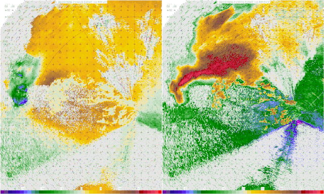
English: A Doppler on Wheels image of a tornadic thunderstorm near La Grange, Wyoming (USA) captured during the VORTEX2 project. In the velocity image on the left, Blues/green represent winds moving towards the radar, and reds/yellows indicate winds moving away from the radar. The reason that some of the darker blues contain red/yellow within them is a trait known as Aliasing, where the winds are moving faster than the radar can detect. In the reflectivity image on the right, the main body of the storm can be seen, with the appendage on the bottom of the storm being a hook echo, which is associated directly with the tornado, and the tornado circulation itself can be seen as the doughnut like shape in the later part of the animation.
Español: Imagen radar de una tormenta de tornados cerca de La Grange (Wyoming), Estados Unidos, producida en el ambito del proyecto VORTEX2. La imagen de la izquierda representa la fuerza de los vientos, en azul los vientos que soplan hacia el radar, y en amarillo/rojo los que se alejan. Los puntos rojos sobre fondo azul son artefactos (aliasing) debidos a vientos que soplan a una velocidad superior al límite de detección del radar. La imagen de la derecha mide la reflectividad, y podemos ver la nube de tormenta principal, así como el eco en cadena del propio tornado. Al final de la animación, vemos el propio tornado, en forma de anillo marrón.
Français : Image Radar d'un orage à tornade près de La Grange, dans le Wyoming (États-Unis) prise dans le cadre du projet VORTEX2. L'image de gauche représente la puissance des vents, avec en bleu les vents soufflant vers le radar, et en jaune/rouge ceux qui s'éloignent. Les taches rouges sur fond bleu sont des artefacts (crénelage) dus à des vents soufflant à une vitesse supérieure à la limite de détection du radar. L'image de droite mesure la réflectivité, on peut y voir le nuage d'orage principal, ainsi que l'Écho en crochet du à la tornade elle-même. En fin d'animation, on voit la tornade elle-même, sous la forme d'un anneau brun.
Українська: Доплерівське зображення торнадної грози поблизу Ла-Грейндж, Вайомінг (США), зроблене під час проекту VORTEX2. На зображенні швидкості ліворуч блакитний/зелений означає вітер, що рухається в напрямку радара, а червоний/жовтий означає, що вітер рухається від радара. Причиною того, що деякі з темних синіх тонів містять червоний/жовтий колір, є особливість, відома як згладжування (аліасинг), коли вітер рухається швидше, ніж може виявити радар. На відбивному зображенні праворуч можна побачити основну частину шторму, при цьому відросток у нижній частині шторму є ехо-гачком, яка безпосередньо пов’язана з торнадо, а саму циркуляцію торнадо можна побачити як форму пончика в пізнішій частині анімації. |
|||||||||||||||||
| Date | ||||||||||||||||||
| Source | http://vortex2.org/dowloops/ | |||||||||||||||||
| Author |
|
|||||||||||||||||
| Permission (Reusing this file) |
||||||||||||||||||
| Other versions | Derivative works of this file: 05june-dow7-wide2.ogv | |||||||||||||||||

| Object location | | View this and other nearby images on: OpenStreetMap |
|---|
Assessment[edit]
|
This image has been selected as picture of the day on Wikimedia Commons for 5 June 2023. It will be captioned as follows: English: A Doppler on Wheels image of a tornadic thunderstorm near La Grange, Wyoming (USA) captured during the VORTEX2 project. In the velocity image on the left, Blues/green represent winds moving towards the radar, and reds/yellows indicate winds moving away from the radar. The reason that some of the darker blues contain red/yellow within them is a trait known as Aliasing, where the winds are moving faster than the radar can detect. In the reflectivity image on the right, the main body of the storm can be seen, with the appendage on the bottom of the storm being a hook echo, which is associated directly with the tornado, and the tornado circulation itself can be seen as the doughnut like shape in the later part of the animation. Other languages:
English: A Doppler on Wheels image of a tornadic thunderstorm near La Grange, Wyoming (USA) captured during the VORTEX2 project. In the velocity image on the left, Blues/green represent winds moving towards the radar, and reds/yellows indicate winds moving away from the radar. The reason that some of the darker blues contain red/yellow within them is a trait known as Aliasing, where the winds are moving faster than the radar can detect. In the reflectivity image on the right, the main body of the storm can be seen, with the appendage on the bottom of the storm being a hook echo, which is associated directly with the tornado, and the tornado circulation itself can be seen as the doughnut like shape in the later part of the animation. Español : Imagen radar de una tormenta de tornados cerca de La Grange (Wyoming), Estados Unidos, producida en el ambito del proyecto VORTEX2. La imagen de la izquierda representa la fuerza de los vientos, en azul los vientos que soplan hacia el radar, y en amarillo/rojo los que se alejan. Los puntos rojos sobre fondo azul son artefactos (aliasing) debidos a vientos que soplan a una velocidad superior al límite de detección del radar. La imagen de la derecha mide la reflectividad, y podemos ver la nube de tormenta principal, así como el eco en cadena del propio tornado. Al final de la animación, vemos el propio tornado, en forma de anillo marrón. Magyar: A VORTEX2 projekt részeként készült radarkép egy tornádóról La Grange közelében (Wyoming, USA). A bal oldali kép a szél erősségét mutatja, kékkel a radar felé fújó szelet, sárgával/pirossal pedig a távolodó szelet. A kék háttéren látható piros pontok a radar érzékelési határértékénél gyorsabban fújó szél okozta artefaktumok (aliasing). A jobb oldali visszaverődési képen a fő viharfelhő látható, valamint maga a tornádó láncvisszhangja. Az animáció végén magát a tornádót látjuk egy barna gyűrű formájában Português: Imagem de radar meteorológico de um tornado perto de La Grange, Wyoming, tirada como parte do projeto VORTEX2. A imagem à esquerda mostra a força do vento, em azul, o vento soprando em direção ao radar e em amarelo/vermelho, o vento soprando para longe. Os pontos vermelhos visíveis no fundo azul são artefatos causados pelo vento soprando mais rápido que o limite de detecção do radar (aliasing). A imagem de reflexão à direita mostra a principal nuvem da tempestade, bem como o eco em cadeia do próprio tornado. Ao final da animação, vemos o próprio tornado na forma de um anel marrom. Українська: Доплерівське зображення торнадної грози поблизу Ла-Грейндж, Вайомінг (США), зроблене під час проекту VORTEX2. На зображенні швидкості ліворуч блакитний/зелений означає вітер, що рухається в напрямку радара, а червоний/жовтий означає, що вітер рухається від радара. Причиною того, що деякі з темних синіх тонів містять червоний/жовтий колір, є особливість, відома як аліасинг, коли вітер рухається швидше, ніж може виявити радар. На відбивному зображенні праворуч можна побачити основну частину шторму, при цьому відросток у нижній частині шторму є ехо-гачком, яка безпосередньо пов’язана з торнадо, а саму циркуляцію торнадо можна побачити як форму пончика в пізнішій частині анімації. |

|
This image has been assessed under the valued image criteria and is considered the most valued image on Commons within the scope: Radar images of thunderstorms. You can see its nomination here. |
Licensing[edit]
This file is licensed under the Creative Commons Attribution-Share Alike 3.0 Unported license.
- You are free:
- to share – to copy, distribute and transmit the work
- to remix – to adapt the work
- Under the following conditions:
- attribution – You must give appropriate credit, provide a link to the license, and indicate if changes were made. You may do so in any reasonable manner, but not in any way that suggests the licensor endorses you or your use.
- share alike – If you remix, transform, or build upon the material, you must distribute your contributions under the same or compatible license as the original.
File history
Click on a date/time to view the file as it appeared at that time.
| Date/Time | Thumbnail | Dimensions | User | Comment | |
|---|---|---|---|---|---|
| current | 23:24, 27 February 2020 | | 1,828 × 1,093 (32.26 MB) | Bürgerentscheid (talk | contribs) | resizing with lanczos3 |
| 22:58, 27 February 2020 |  | 1,828 × 1,093 (29.76 MB) | Bürgerentscheid (talk | contribs) | resized to fit 100 MP limit. | |
| 03:28, 15 November 2009 |  | 1,912 × 1,144 (28.73 MB) | Ks0stm (talk | contribs) | {{Information |Description={{en|1=A Doppler on Wheels radar loop; velocity on the left, reflectivity on the right.}} |Source=http://vortex2.org/dowloops/ |Author=Joshua Wurman, Center for Severe Weather Research |Date=2009-06-05 |Permission={{OTRS pending |
You cannot overwrite this file.
File usage on Commons
The following 47 pages use this file:
- User:Andrew J.Kurbiko/POTD/2023
- User:Gusme/+1
- User:JPxG/Favorites
- User:Kaldari/Potd
- User:Kaldari/PotdFullYear
- User:Kaldari/PotdFullYear/June
- User:Miya/FPs
- User:Miya/FPs/2010/02
- User:Miya/FPs/2010/02/table
- User:संतोष दहिवळ/POTD full next
- User:सुभाष राऊत/POTD full next
- User talk:Ks0stm/Archive 1
- Commons:Dagens bild/nästa månader
- Commons:Featured picture candidates/File:05june-dow7-wide.ogv
- Commons:Featured picture candidates/Log/February 2010
- Commons:Featured pictures/Animated
- Commons:Featured pictures/chronological/2010-A
- Commons:Picture of the Year/2010/Galleries/2010-A
- Commons:Picture of the Year/2010/Galleries/All
- Commons:Picture of the Year/2010/Galleries/Diagrams
- Commons:Picture of the Year/2010/Galleries/Diagrams/Large
- Commons:Picture of the Year/2010/Galleries/Diagrams/Small
- Commons:Picture of the Year/2010/Galleries/Index/2
- Commons:Picture of the Year/2010/Galleries/Index/Animated
- Commons:Picture of the Year/2010/Galleries/Index/Diagrams
- Commons:Picture of the Year/2010/Galleries/Table
- Commons:Picture of the Year/2010/Galleries/Table/02
- Commons:Picture of the Year/2010/R1/File:05june-dow7-wide.gif
- Commons:Picture of the Year/2010/Results/R1/ALL/Table
- Commons:Picture of the Year/2010/Results/R1/Diagrams
- Commons:Picture of the Year/2010/Results/R1/Diagrams/Table
- Commons:Valued image candidates/05june-dow7-wide-gif
- Commons:Valued image candidates/05june-dow7-wide.ogv
- Commons:Valued images by topic/Science/Engineering
- Commons:WikiProject Aviation/recent uploads/2020 February 27
- Commons talk:Picture of the Year/2010/Galleries/Table
- Commons talk:Picture of the Year/2010/Results/R1/ALL/Table
- File:05june-dow7-wide.ogv (file redirect)
- File:05june-dow7-wide2.ogv
- Template:Potd/2023-06
- Template:Potd/2023-06-05
- Template:Potd/2023-06-05 (en)
- Template:Potd/2023-06-05 (es)
- Template:Potd/2023-06-05 (hu)
- Template:Potd/2023-06-05 (pt)
- Template:Potd/2023-06-05 (uk)
File usage on other wikis
The following other wikis use this file:
- Usage on bn.wikipedia.org
- Usage on en.wikipedia.org
- Hook echo
- Doppler on Wheels
- User:Daniel Mietchen/Science communication gallery
- Wikipedia:Featured picture candidates/Hook echo
- Wikipedia:Featured picture candidates/February-2010
- Wikipedia:Featured picture candidates/September-2012
- Wikipedia:Featured picture candidates/Hook echo 2
- Wikipedia:Featured picture candidates/Hook echo 3
- Wikipedia:Featured picture candidates/May-2017
- Usage on hu.wikipedia.org
- Usage on ko.wikipedia.org
- Usage on myv.wikipedia.org
- Usage on pl.wikipedia.org
- Usage on pt.wikipedia.org
- Usage on ru.wikipedia.org
- Usage on uk.wikipedia.org
- Usage on uz.wikipedia.org
- Usage on vep.wikipedia.org
- Usage on vi.wikipedia.org