Commons:Graphic Lab/Map workshop
| Illustration Workshop | Map Workshop | Photography Workshop | Video and Sound Workshop |
 Map workshop
This workshop is part of the Graphics Lab, a project aimed at picture retouching to improve the graphical content of the Wikimedia projects. More information about the lab can be found on its main page and requests pages (Illustrations ; Photographs ; Maps ; Video and Sound). To ask questions or make a suggestions, see the talk page of the graphic lab page.
This specific page is the requests page for the Map Workshop. Anyone can make a request for a map to be created or improved. The standard format for making a request is shown below, along with general advice, and should be followed.
Make a request
Use the following template when making a new request, replacing the examples with your image(s) and request(s):
<gallery>
 IMAGENAME.EXT|Description of image
 IMAGE#TWO.EXT|2nd image (If there is one)
 ETCETCETC.EXT|Don't request too many at once, though
</gallery>

;Request:
: Details of your request go here… --~~~~
;Graphist opinion(s):
See also[edit]
| SpBot archives all sections tagged with {{Section resolved|1=~~~~}} after 7 days and sections whose most recent comment is older than 185 days. For the archive overview, see /Archive. The latest archive is located at /Archive/2023. | |
Highlight East timor[edit]
.svg/120px-Indonesia_1976-1998_(orthographic_projection).svg.png)
Indonesia in 1993 with east timor
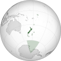
Reference 2
.svg)

Article(s): New Order
- Request
- Please Highlight East Timor like New Zealand territories in the second image. Also change the color please.
- Graphist opinion(s)
Pinging @Mhatopzz, Can you clarify what you're wanting here? Do you want East Timor highlighted in a solid color (but different from the green used on New Zealand)? Do you want East Timor highlighted with a shaded circle like the New Zealand territories, but a different color? Do you want only East Timor highlighted (removing the color/shading on NZ and the highlighted territories)? Thanks, Tcr25 (talk) 15:51, 7 December 2022 (UTC)
File:Krystal-vs-whitecastle-locations-map.svg[edit]

Description of first image
- IMAGE2.EXT
Description of second image (if needed)
- IMAGE3.EXT
Description of third image (if needed; don't request too many at once, though)

Article(s):
- Request
- Please make Florida purple as it has both White Castle and Krystal.2600:100C:A200:39BC:A586:BA5F:6957:87A
- Graphist opinion(s)
Inner-Asian "civilisations"[edit]
_Azerbaijan.png/120px-Map_of_the_historical_region_of_(Iranian)_Azerbaijan.png)
An image of Iranian Azerbaijan to help you to locate it.

An image showing how Xinjiang can be divided based on the Chinese administrative subdivisions (even if based on the real geographic mountains, it can be better).

A map helping you to locate the Great Wall going all the way from Shanhai, Hebei to Jiayuguan, Gansu.

A map helping you to locate the rivers I’m talking about in Russia.
_Azerbaijan.png)


Article(s): Various and many, mainly related to politics, anthropology, linguistics, archeology, history and political ideologies
- Request
The map I need shows 5 territories in different colors. The map should be a flat world map that people can easily modify, like the ones usually found on Wikipedia. Several copies of the map can be exported, one without the borders of the countries of the world, one with the borders of the countries of the world and one in orthographic projection. If you don't have time, the simple one without the borders of the countries of the world will suffice. Attention, one of the territories represented on the map is itself divided by several borders.
1) "Japan" (bc002d color) :
Includes all the current Japan (main islands, islets, Nansei archipelago, etc.), Senkaku, the Kuril Islands, Sakhalin Island and the Kamchatka Peninsula.
2) 2) "Korea" (0055ff) :
Includes both Koreas (everything south of the Tumen River) and Jiandao (Gando).
3) "Turkic-Mongolic-Tungusic" :
You should draw the in this order for not getting in trouble.
3.1) "Western Turkic" (0099dd) :
Include Turkey, Northern Cyprus, Iranian Azerbaijan (West Azerbaijan, East Azerbaijan and Ardabil provinces of Iran), Azerbaijan.
3.2) "Mongolia" (0000ff) :
Includes all of Outer Mongolia and all of Inner Mongolia, including territories that seem to have been cut off from it such as the Josutu League or the Southern Chahar region in northern Hebei. Include everything located between the southern border of Inner Mongolia and the Great Wall of China as well. The part of Russia surrounded by Amur river, Outer Mongolia, Yenisei river-Angara river, Baikal lake, Lena river-Aldan river, Stanovoi range and Okhotsk sea is also included as "Mongolia".
3.3) "Manchuria" (ffcc22) :
Everything surrounded by "Mongolia" you drawn at the west, Amur river flowing to Sakhalin in the North, the sea at the east, Korea at the south and then use the Great Wall as a border with China until it reaches the Mongolian territory you drew that also use the Great Wall as a border with China. In China, it mainly covers the Jilin, Heilongjiang and Liaoning as well as some parts of others provinces like Hebei that are located at the North of the Great Wall.
3.4) "Northern, Southern and Eastern Turkic" (0099dd, same than Western Turkic) :
3.4.1) Territory :
Central Asia including Tajikistan, Wakhan Corridor in Afghanistan and in Russia : all of the lands located at the East of Tobol-Irtysh-Ob in Siberia that do not belong to "Mongolia", "Manchuria" or "Japan" until the Bering Strait. In China, include everything located in the North of the Tibetan Plateau and the Great Wall that you didn’t gave to "Mongolia" and "Manchuria", mainly it’s northern Gansu and Xinjiang.
3.4.2) Borders :
As you can see, this territory should be divided in 3 : Eastern, Northern and Southern. The border used between the Eastern "Turkic" part and Northern "Turkic" part is the Yenisei river. The border between the Southern "Turkic" and Northern "Turkic" is composed of : • In Turkmenistan, any natural border between the Caspian sea and the Aral sea. • The Aral sea itself crossed by the border in its middle. • The Syr-Daria river. • Any natural link between Syr-Daria river and the Altishahr-Dzungaria border. • In Xinjiang, the natural border between Dzungaria and Altishahr (Tarim Basin). Everything further, such as the "Turkic" part in Gansu located in the North of the Great Wall and finally reaching "Mongolia", belong to "North Turkic".
4) Other (light grey) :
• Turkmen-Uzbek little regions in the North of Afghanistan, Afghanistan.
• Zanjan province, Iran
• Gagauzia, Moldavia
• Astrakhan Oblast, Russia
• Bashkortostan, Russia
• Chuvashia, Russia
• Crimea, Ukraine/Russia
• Daghestan, Russia
• Kabardino-Balkaria, Russia
• Karachayevo-Cherkessia, Russia
• Tatarstan, Russia
• Regions of Russia located between Kazakhstan and Bashkortostan-Chuvashia-Tatarstan, Russia.
• The area between the Ural Mountains (historical border between Europe and Asia) and the Tobol-Irtysh-Ob, Russia. — Preceding unsigned comment added by EpicDiscoMarmot (talk • contribs) 21:49, 20 March 2022 (UTC)
- Graphist opinion(s)
Who made this request?
It's extensive and would need you being involved in the work all the way. So please sign this and ping me and I can help you, thanks. --please ping me-- Goran tek-en (talk) 14:22, 23 November 2022 (UTC)
- @Goran tek-en: , it was made by user "EpicDiscoMarmot" back on 21:49, 20 March 2022. This is their only edit so it is entirely possible that they have abandoned their account or forgot their password. Anyhow, hopefully they'll see this ping and (finally) respond. --Donald Trung 『徵國單』 (No Fake News 💬) (WikiProject Numismatics 💴) (Articles 📚) 19:12, 11 April 2023 (UTC)
Korean Islands Problems[edit]
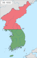
Korean War Map

Article(s): Korean War
- Request
- Issue A: Baengnyeongdo is under South Korean administration.
Issue B: Ulleungdo, larger than Baengnyeongdo, is omitted from the map. See page for details.
--Geographyinitiative (talk) 17:46, 9 July 2022 (UTC)@Geographyinitiative I could help you with this but I will need your help along the way as the description page describes more and other specific issues depending on which image (time/frame) in the GIF animation we are talking about.So please get back to me if you will be here to help me with your knowledge, thanks. --please ping me-- Goran tek-en (talk) 14:08, 23 November 2022 (UTC)@Geographyinitiative Do need your assistance, just ping me and add needed info, thanks. --please ping me-- Goran tek-en (talk) 15:57, 1 March 2023 (UTC)- @Goran tek-en: I am not a Korea expert. However, (A) the 07.1953 image shows Ongjin County, Incheon (including Baengnyeongdo) in pink, whereas the armistice says that those islands are under ROK administration (as they are at til now). Further (B) Ulleungdo is not shown on the map at all, despite being larger than Baengnyeongdo and being within the lat/long scope of the map. That's truly all I know. I would suggest that Issue (B) is easier to resolve since I don't know that the ROK ever lost that island in the war (but again, I don't know- they might have lost it and regained it, idk). Issue (A) is hard to resolve because they were presumably lost and then regained at some point, but I don't know that history. I would suggest that Issue (B) could be solved quickly and easily as a separate upload, and then Issue (A) could be looked at later. However, Issue (A) is more serious than Issue (B) because it shows present-day ROK controlled areas as part of the DPRK in 07.1953. The wording of the 1953 Armistice implies that Baengnyeongdo is ("shall remain") under ROK administration. --Geographyinitiative (talk) 16:08, 1 March 2023 (UTC)
@Geographyinitiative I have zero knowledge, it's always up to the requester to provide the info/knowledge needed, we as graphic workers do just that, graphic work.- I can add that island
- which color should it be
- should it be in all frames
- I can add that island
--please ping me-- Goran tek-en (talk) 16:32, 1 March 2023 (UTC)- @Goran tek-en: The final image is definitely wrong. I don't know the history well enough to work on the wartime maps. If you want my final word: Change Baengnyeongdo to green in the final image and in that same final image add Ulleungdo, also colored green. Technically it will introduce a "discontinuity" between the maps to add one map that has Ulleungdo while the others don't, but the added value of not ignoring Korean territory is strong and I hope this would get people interested at some point. Also, we don't know exactly when Baengnyeongdo became green, but the mistake of having territories that were S. Korean at the end of the war colored pink in the final map is disastrous. This is a stop-gap measure. --Geographyinitiative (talk) 12:23, 8 March 2023 (UTC)
- This book says the UN forces had complete maritime dominance, and explicitly mentions control in July 1951. I'd suggest that the islands simply stay green from at least the current turning green in 11.1950 until the end. Chipmunkdavis (talk) 13:54, 8 March 2023 (UTC)
- @Goran tek-en: The final image is definitely wrong. I don't know the history well enough to work on the wartime maps. If you want my final word: Change Baengnyeongdo to green in the final image and in that same final image add Ulleungdo, also colored green. Technically it will introduce a "discontinuity" between the maps to add one map that has Ulleungdo while the others don't, but the added value of not ignoring Korean territory is strong and I hope this would get people interested at some point. Also, we don't know exactly when Baengnyeongdo became green, but the mistake of having territories that were S. Korean at the end of the war colored pink in the final map is disastrous. This is a stop-gap measure. --Geographyinitiative (talk) 12:23, 8 March 2023 (UTC)
- @Goran tek-en: I am not a Korea expert. However, (A) the 07.1953 image shows Ongjin County, Incheon (including Baengnyeongdo) in pink, whereas the armistice says that those islands are under ROK administration (as they are at til now). Further (B) Ulleungdo is not shown on the map at all, despite being larger than Baengnyeongdo and being within the lat/long scope of the map. That's truly all I know. I would suggest that Issue (B) is easier to resolve since I don't know that the ROK ever lost that island in the war (but again, I don't know- they might have lost it and regained it, idk). Issue (A) is hard to resolve because they were presumably lost and then regained at some point, but I don't know that history. I would suggest that Issue (B) could be solved quickly and easily as a separate upload, and then Issue (A) could be looked at later. However, Issue (A) is more serious than Issue (B) because it shows present-day ROK controlled areas as part of the DPRK in 07.1953. The wording of the 1953 Armistice implies that Baengnyeongdo is ("shall remain") under ROK administration. --Geographyinitiative (talk) 16:08, 1 March 2023 (UTC)
@Geographyinitiative Chipmunkdavis I'm sorry but I will not proceed with any changes to this gif image when there is not someone who with certainty can tell me what to change, how and when. Please discuss this somewhere else and when there is an agreement on what to change and how, you can ping me and I will do it. As for now it's all to confusing for me, hope for your understanding, thanks. --please ping me-- Goran tek-en (talk) 16:54, 8 March 2023 (UTC)
- Graphist opinion(s)
File:US and Russian bases and facilities.jpg[edit]

File:US and Russian bases and facilities.jpg

Article(s): Numerous articles across Wikipedia.
- Request
- In File:US and Russian bases and facilities.jpg:
- Azerbaijan needs to be colored in white, because Azerbaijan never hosted a US military base, nor does it host a Russian base.
- Georgia needs to be colored in blue (like Belarus, Moldova and Armenia), because Georgia never hosted a US military base. It only has Russian military bases in breakaway Abkhazia and South Ossetia.
- The border of South Sudan, which became independent in 2011, needs to be added. Both South Sudan and Sudan do not host any US or Russian military bases, so their color stays unchanged. --Maphobbyist (talk) 18:40, 20 October 2022 (UTC)
- Graphist opinion(s)
![]() Request taken by --please ping me-- Goran tek-en (talk) 20:02, 9 February 2023 (UTC)
Request taken by --please ping me-- Goran tek-en (talk) 20:02, 9 February 2023 (UTC)
 Done @Maphobbyist: You have to check this and if fine mark it resolved, thanks. --please ping me-- Goran tek-en (talk) 20:19, 9 February 2023 (UTC)
- @Goran tek-en: --Maphobbyist (talk) 20:59, 13 February 2023 (UTC)
- @Maphobbyist Why did you ping me without any message for those two requests?
- If you want to close/archive them you have to put out the code I described for you. --please ping me-- Goran tek-en (talk) 13:17, 14 February 2023 (UTC)
- @Goran tek-en: --Maphobbyist (talk) 20:59, 13 February 2023 (UTC)
Post-imperial organisations map - Gabon, Togo, Vanuatu, The Gambia and the Maldives[edit]

Article(s): Any article this map already appears on.
- Request
- Alright, could someone please make the following changes to the above map:
- 1) Gabon and Togo joined the Commonwealth of Nations on 25 June 2022, while also retaining their membership of La Francophonie, hence they should be changed to blue-and-red stripes (like Canada, Cameroon and Rwanda) to refect that.
- 2) Vanuatu has been a member of both the CON and LF since independence, so it should also have blue-and-red stripes.
- 3) The Gambia and the Maldives rejoined the Commonwealth in 2018 and 2020 respectively, so they should both be changed from white to red.
- Thanks. Snow Lion Fenian (talk) 16:07, 6 November 2022 (UTC) Snow Lion Fenian (talk) 13:16, 5 March 2023 (UTC) Snow Lion Fenian (talk) 11:12, 4 May 2023 (UTC)
- The Gambia has also been back in the Commonwealth for some years but is blank on the map at present. GPinkerton (talk) 16:14, 7 November 2022 (UTC)
- @GPinkerton: Thanks for pointing that out. I've now updated the request accordingly. Snow Lion Fenian (talk) 00:23, 6 January 2023 (UTC)
- The Gambia has also been back in the Commonwealth for some years but is blank on the map at present. GPinkerton (talk) 16:14, 7 November 2022 (UTC)
- Graphist opinion(s)
Requesting new versions of two maps with new colours[edit]

Global map of countries by age of which people can vote.

Global map of countries by age of which people attain adulthood


Article(s): en:Age of majority, en:Voting age
- Request
- Request that a new version of hese maps be created that uses different, distinct colours for each age. Some colours, such as those used for age 20 and 17, and 18 and 16 are too similar to each other and can lead to confusion, especially for those with sight issues. Suggested alternate colours: red, black, blue, yellow, purple, and green. Editor ping upon request - Goran tek-en. Helper201 (talk) 17:44, 26 November 2022 (UTC)
- Graphist opinion(s)
![]() Request taken by --please ping me-- Goran tek-en (talk) 18:14, 26 November 2022 (UTC)
Request taken by --please ping me-- Goran tek-en (talk) 18:14, 26 November 2022 (UTC)
@Helper201- ----
- Those drafts are PNG versions of the original SVG file I'm working in and will upload to commons.
- Those drafts are shown for proofreading only.
- ----
Age_of_Majority_-_Global-1, I have checked so those colors should work for most people with color deficiency, feedback thanks. --please ping me-- Goran tek-en (talk) 18:23, 28 November 2022 (UTC)@Helper201 I do need your support as above to be able to continue the work on your request, thanks. --please ping me-- Goran tek-en (talk) 11:30, 2 December 2022 (UTC)@Goran tek-en I think the colours for 16 and 21, as well as 19 and 20 are too similar to each other, being shades of the same colour. Helper201 (talk) 00:46, 6 December 2022 (UTC)- @Helper201 If you have any color deficiency please tell me so I can try to view it like you do.
- In this image-colors picked, you can see which colors I picked for each age (where the black lines are). They are not "shades of the same color". Below there are colors for the three most common color deficiencies, there some colors are different shades but not the ones you are writing about.
So I'm sorry, I don't understand what you mean, please try to explain in another way, thanks. --please ping me-- Goran tek-en (talk) 12:20, 6 December 2022 (UTC)- Hi @Goran tek-en, Sorry, I didn't see the offer to help here. I reworked the Voting Age map already using the Okabe–Ito Color Universal Design colorblind-safe palette. I didn't do anything with the Age of Majority map (I hadn't seen that request), but if you use the CUD palette, you should be good for most colorblind users. — Tcr25 (talk) 13:52, 6 December 2022 (UTC)
@Tcr25: , @Helper201: I did use a 12-color palette for color deficiency for those colors.
As you have updated one of those maps (I couldn't know you were working on it as you hadn't "taken it" here.) I think the best is if you do the other also and please use the codes provided here so others can see who is working on what so we don't do double work, thanks. So hereby I withdraw my "take". --please ping me-- Goran tek-en (talk) 15:00, 6 December 2022 (UTC)
- Sorry about that @Goran tek-en. I saw the request that was made on the Voting Age file's page, and only found the request here after that update was done. — Tcr25 (talk) 15:46, 6 December 2022 (UTC)
- @Tcr25 No problem, just glad you are working on this, thanks. --please ping me-- Goran tek-en (talk) 18:26, 6 December 2022 (UTC)
- Both maps now Done, so ... Tcr25 (talk) 18:32, 6 December 2022 (UTC)
- @Tcr25 @Goran tek-en I still think the colours for 19 and 20, and 17 and 21 are too similar to each other, being they are simply different shades of the same colour (two shades of blue and two shades of orange). Maybe change one to brown and another to purple, or some other completely different colours. Helper201 (talk) 04:23, 9 December 2022 (UTC)
- @Helper201: , 19 and 20 are shades of blue, 16 and 21 are shades of orange, but they're quite distinct from one another. They also resolve well for most forms of colorblindness (according to simulation tools), although it is clearest for readers with deuteranopia. Adding purple and brown to the mix would likely decrease accessibility by creating more pairs that colorblind users cannot distinguish between. — Tcr25 (talk) 13:26, 9 December 2022 (UTC)
- @Tcr25 @Goran tek-en I still think the colours for 19 and 20, and 17 and 21 are too similar to each other, being they are simply different shades of the same colour (two shades of blue and two shades of orange). Maybe change one to brown and another to purple, or some other completely different colours. Helper201 (talk) 04:23, 9 December 2022 (UTC)
- Both maps now
- @Tcr25 No problem, just glad you are working on this, thanks. --please ping me-- Goran tek-en (talk) 18:26, 6 December 2022 (UTC)
Turkey vulture range map[edit]

Current JPG unsourced range map

Article(s): en:Turkey vulture ![]()
- Request
- Hi! Our current range map is an unsourced JPG file that doesn't match with the IUCN's map (especially in Uruguay). An SVG file based on a reliable source would be amazing: BirdLife International. 2018. Cathartes aura. The IUCN Red List of Threatened Species 2018: e.T22697627A131941613. https://dx.doi.org/10.2305/IUCN.UK.2018-2.RLTS.T22697627A131941613.en. Accessed on 14 December 2022. Thanks for any help you can provide. --A455bcd9 (talk) 11:20, 14 December 2022 (UTC)
- Graphist opinion(s)
New topographic map of Chongqing – issues[edit]
Article(s): cs:Čchung-čching (Czech Wiki)
- Request
- Hello, I'm trying to make a new, detailed, topographic map of Chongqing, a province-level municipality in China, however I'm having issues uploading it: the Upload Wizard states that "This file did not pass file verification." The map was made in QGIS, then I added name labels of the various mountain ranges (in Czech language), and added some finishing touches in Inkscape (scale, elevation legend etc.). I've tried to figure out what's wrong (validation), and there seem to be some issues with whatever I add on top of the bare map (text, labels, etc.), however I don't think I'd know how to fix it. Here's a Catbox link to the .svg map, feel free to download it, change it and, hopefully, correct it! Also - I'm not sure whether the size is appropriate, I'd like the map to be fully readable after a zoom-in, so please feel free to enlarge it if you see fit. Thank you! --Kubeji (talk) 22:30, 28 December 2022 (UTC)
- I'm taking a look at it! Remsense (talk) 22:51, 2 February 2023 (UTC)
- Graphist opinion(s)
Psilocybin decriminalization in the United States[edit]

Article(s): en:Psilocybin decriminalization in the United States
- Request
- Colorado should be updated as it has decriminalized psilocybin across the whole of the state. Licensed "healing centers" for medical use are expected to begin in 2024. For now the whole of Colarado should be dark blue to indicate "Decriminalized" according to the key. When the licensed healing centers are established in 2024 or later it can be changed to purple like Oregon. For now the state just needs updating to decriminalized.
Sources:
- https://time.com/6232212/colorado-decriminalizes-psychedelics-psilocybin-proposition-122/
- https://www.independent.co.uk/news/world/americas/us-politics/midterm-elections-2022/colorado-mushrooms-legal-proposition-122-b2223322.html
Helper201 (talk) 03:12, 6 January 2023 (UTC)
- Graphist opinion(s)
![]() Request taken by A455bcd9 (talk) 13:21, 6 January 2023 (UTC)
Request taken by A455bcd9 (talk) 13:21, 6 January 2023 (UTC) ![]() Done
Done
Map of volcanoes in Guatemala[edit]

Map of the volcanoes in Guatemala

Map of Guatemala in Inari Sámi


Article(s): Listo Guatemala tullâvaarijn
- Request
- I would like only the Guatemalan volcano symbols and labels in the first image to be added to the Inari Sámi map of Guatemala in the second image and saved as a new file so we can use it in an article on the Inari Sámi wikipedia. The volcano labels are missing the diacritics in the gif and the following labels would need to be fixed: Santa María, Atitlán, and Tolimán. I would also appreciate if the symbol and label colors could match the SVG image color scheme better than the bright red of the GIF. Takkâ! :) --Yupik (talk) 09:04, 11 January 2023 (UTC)
- Graphist opinion(s)
Norwegian polling graph update and alteration/axis extension[edit]

Norwegian Opinion Polling, 30 Day Moving Average, 2021-2025

Article(s): * en:2025 Norwegian parliamentary election
* en:Opinion polling for the 2025 Norwegian parliamentary election
- Request
- Graph update and axis extension.
- Can someone please update this polling graph using the latest polls on the English Wikipedia page above so it is up to date, including the 30-day averages bar charts? Can someone also please extend the Y percentage axis to 40% as the Conservative Party (H) have polled over the current maximum of 30% on the graph and gone above 35% in a poll to 35.6%. Helper201 (talk) 16:24, 17 January 2023 (UTC)
- Graphist opinion(s)
Virginia and Colorado historical county maps[edit]

Standardized map of Virginia

Standardized map of Colorado

Example of what I am talking about as shown in the old style


Article(s): [[]]
- Request
- Hello needing someone who could draw accurately and tweak the new standardized Virginia and Colorado maps to make the county boundaries historically accurate for past election articles. For Virginia needing it to include the Independent city of Bedford within Bedford County. For Colorado, needing Broomfield county removed. Not sure which programs were used to make the original base map but I used inkscape to edit the colors of the county for election articles.
- Details of your request go here… --Putitonamap98 (talk) 01:18, 21 January 2023 (UTC)
- Graphist opinion(s)
Costco Map[edit]

Description of first image

This file, including China, already exists
- IMAGE3.EXT
Description of third image (if needed; don't request too many at once, though)


Article(s): en:Costco
- Request
- Please add China to the list. http://www.news.cn/english/2021-12/08/c_1310358751.htm --208.127.190.114 21:12, 21 January 2023 (UTC)
- Graphist opinion(s)
- There is no need for this request becauseThis image already exists and it is in the article. Ww2censor (talk) 22:59, 21 January 2023 (UTC)
Change map from jpg to svg to later improve the result[edit]
My following request was earlier today posted at the Commons:Help desk but I was informed I better make the request here.
I would like to use this 1968 map in Commons and create a new map in SVG format with different background colors of the historical districts of Suriname. A little bit like this map, so maintaining the city/village names, mayor roads, lakes, rivers etc. But then in SVG format of the situation in 1968. I guess I should start with a jpg to svg conversion tool to easily import the lines for the borders, rivers, roads, etc. in a vector/line format and then use a tool like Inkscape to process it in the way I want. Unfortunately the district borders are not shown as a solid line but a repetition of a small line, a dot, another small line and another dot and so on. Can somebody here give me some advice how to start this. Is using a free svg conversion tool a good first step and if so, which one would you use to overcome the problem with the district border lines? Or would you start by importing the jpg file into some free PC software program like Inkscape and let that program do the conversion of the pixels of say a river into lines that can be scaled? Any advice would be appreciated. - Robotje (talk) 17:06, 24 February 2023 (UTC)
- @Robotje Using any (I believe so) conversion/tracking tool will give you a bad result. To me the solution is to import the jpg to e.g. Inkscape but also import high quality screenshots from OpenStreetMaps and other sources with rivers etc. Then you will have to manually draw what ever need in your map and please use file:Maps template-en.svg so that you try to keep the conventions we have. --please ping me-- Goran tek-en (talk) 17:22, 24 February 2023 (UTC)
Meitei language geographical distribution map[edit]
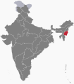
Manipur state

Assam state

Tripura state

Northeast India

Sylhet division (not Sylhet district)

Sagaing region

Mandalay region

Yangon region
- And a few more maps whose links I added in my request statement


- Request
- Hello! May I request you to make a map in which (1) "Manipur" is in the darkest colour, (2) Assam and Tripura states in a lighter colour, (3) remaining "Northeast Indian states" in the little lighter colour, (4) Bangladesh's Sylhet division (not to be confused with Sylhet district) and the Sagaing region of Myanmar in a lighter colour, (5) the Mandalay region and the Yangon region, File:Ayeyarwady Region in Myanmar.svg, File:Bago Region in Myanmar.svg, File:Shan State in Myanmar.svg & File:Kachin State in Myanmar.svg in a little lighter colour, which is for the regions where Meitei language is spoken with respect to concentration of population? Fortunately, the said portions of areas in the 3 neighboring countries are demarcated properly in various svg maps available in the Commons. --Haoreima (talk) 16:09, 13 March 2023 (UTC)
- Graphist opinion(s)
Simple map(s) of Finnish Defence Forces Areas of Responsibility from early 1950s[edit]

A potential base map

Article(s): en:User:Ljleppan/Polttoainehankinta
- Request
- (Moved from Commons:File requests)
- I'm not certain what the best source map would be, but I'd appreciate a Commons-compatible version of the map of Figure 6 (page 37) of this PDF (also accessible via this link) for the draft currently at en:User:Ljleppan/Polttoainehankinta. In addition to the Areas of Responsibility, it would be good to show the locations of en:Helsinki, en:Porkkala and a few of the larger cities (Perhaps en:Turku, en:Vaasa, en:Oulu, en:Rovaniemi and en:Ivalo if possible without sacrificing legibility?).
- I'd also greatly appreciate Commons-version of the map(s) in Figure 5 (page 31) of the same PDF, but that's less of a priority.
- Graphist opinion(s)
Creating Maps of Talukas(sub-district) of Gujarat[edit]
- Request
I have a request for making maps of Talukas(sub-districts) of Gujarat districts.Can you make some maps of Talukas of districts of Gujarat, India.
Here are the talukas list - Talukas of Gujarat: link

Similar to this(Ahmedabad district talukas map)

Checkout Some available maps:
- [File:Gujarat Talukas Map 2011.svg] but it's old version. "In 2013 some new District has been created".
- [1]
- [2]
- [3]
- [4]
- [5]
- [6]
DSP2092 (talk) 06:21, 27 March 2023 (UTC)
- Hi, I found this source, seems updated to 2018, but the administrative division is different than the one in your images (see here a quick export). Is it correct? In case i can generate the map. The best solution would be to find geographical shapefiles from official indian sources Sette-quattro (talk) 07:32, 31 March 2023 (UTC)
- Yes it's a Gujarat Sub-districts (talukas) map.If there's a full map of Gujarat.It's not a complete map. DSP2092 (talk) 17:06, 2 April 2023 (UTC)
- Yes there is the whole country, my question is if the division of sub-distritcs is correct. Do you need one map of all the sub-dostricts of Gujarat, or multiple maps (e.g. one per district)? Sette-quattro (talk) 20:31, 5 April 2023 (UTC)
- Yes it's a Gujarat Sub-districts (talukas) map.If there's a full map of Gujarat.It's not a complete map. DSP2092 (talk) 17:06, 2 April 2023 (UTC)
- Graphist opinion(s)
![]() Request taken by Sette-quattro (talk) 16:12, 6 April 2023 (UTC)
Request taken by Sette-quattro (talk) 16:12, 6 April 2023 (UTC)
File:Taiwan relief location map.jpg[edit]
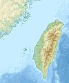
File:Taiwan relief location map.jpg

Article(s): en:Liang Island en:Dongyin, Lienchiang, all Taiwan articles
- Request
- Straightforward fix of map
- In 2019, I literally used Microsoft Paint to put a temporary fix on the map of Taiwan. The dotted line around the Matsu Islands did not extend around en:Dongyin, Lienchiang. The map urgently needs to be changed to (1) add some extra space above Dongyin and (2) put the dotted line in that extra space. Here's a great example of what should be done: [7] (map of Taiwan on lower right). This is not a minor issue or something that can wait four years- it is a travesty of the highest order, and frankly, it's dangerous. It may be arduous to make the change- and the map as is "kinda works"-, but ultimately it undercuts the credibility and reliability of Wikipedia to have something f'ed up this badly. It's like if Ukraine's Snake Island was right on the edge of the map and it wasn't clear if it was part of Ukraine or not. This is not a minor issue, this is big. A mountain imagined as a mole hill is a mountain. --Geographyinitiative (talk) 19:26, 31 March 2023 (UTC)
- Graphist opinion(s)
13 Colonies map into US English[edit]

Map of the Thirteen Colonies what appears to be German

Article(s): en:Thirteen Colonies, en:United States, en:European colonization of the Americas, en:British colonization of the Americas, en:United Colonies,
- Request
- Could someone make a version of this map in US English?
- The idea is to have a good map in English of the Thirteen Colonies as they existed in 1775 before the US Declaration of Independence: a map that is not anachronistic—that is, a map that doesn't show boundaries of US states that did not exist at the time. إيان (talk) 23:30, 2 April 2023 (UTC)
- Graphist opinion(s)
File:Bohaiseamap2.png[edit]
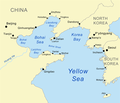
File:Bohaiseamap2.png

Article(s): w:Bohai Sea, w:Yellow Sea
- Request
- I suggest using the more normative 'Pyongyang' and 'Yellow River' or at least adding these forms in parentheses. --Geographyinitiative (talk) 11:03, 3 April 2023 (UTC)
- Graphist opinion(s)
Chronological map of NATO membership as animated SVG[edit]
Article(s): en:Enlargement of NATO
- Request
- This animated GIF of the chronology of NATO membership looks awful. I've again had to update it manually today, and really with it could be recreated either as a higher resolution GIF with smoother animation, or perhaps an animated SVG that might be both cleaner and easier to update. The only small trick is the borders in Europe should match the year each member joined. Thanks! -- Patrick, oѺ∞ 18:23, 4 April 2023 (UTC)
- Graphist opinion(s)
Creating Maps of Gujarat Legislative assembly constituencies[edit]
For List of Legislative Assembly Constituencies: en:Demographics of districts of Gujarat#Demographics
Article(s): en:List of constituencies of the Gujarat Legislative Assembly (for creating Legislative Assembly Constituencies)
- Request
- Making individual Gujarat Legislative Assembly Constituencies Maps from Gujarat Legislative Constituency Map

Gujarat Legislative Assembly Map

Example Maps of different Indian state for making Gujarat maps:
- en:List of constituencies of the Tamil Nadu Legislative Assembly#Current list of constituencies(making individual Legislative constituencies link this)
--DSP2092 (talk) 03:10, 10 April 2023 (UTC)
Map of Bruttium[edit]

Map of Bruttium

Article(s): el:Βρεττία, es:Brucio, de:Bruttium and all other articles on the same subjects in other languages
- Request
- Please remake the file of map of Bruttium to svg format, so that it is easy to translate. I am interested in the Greek translation, but I will give both the Latin and Greek names used in the map
- I suspect you will know better than me whether it is worth copying this map or better to copy a map of the Italian peninsula already in svg. The names of the cities from top to bottom, from left to right as shown below. First in Latin, then in Greek. Please make a map in Greek and one map in Latin. For the translation in Latin I am using the detailed map of Shepherd File:Shepherd-c-030-031.jpg.
- Roma / Ρώμη
- Lucania / Λευκανία
- Laus / Λᾶος
- Sybaris / Σύβαρις
- Thurii / Θούριοι
- Bruttium / Βρεττία
- Tempsa / Τεμέση
- Crotona / Κρότων
- Terina / Τερίνα
- Scylletium / Σκυλλήτιον
- Medma / Μέδμα
- Caulonia / Καυλωνία
- Locri / Λοκροί (the full name is Epizephyrii Locri / Επιζεφύριοι Λοκροί, if you can fit it, please do)
- Rhegium / Ρήγιον
Let me know if I can help. --FocalPoint (talk) 19:52, 13 April 2023 (UTC)
- Graphist opinion(s)
[edit]
If you have some experience with identifying some of the best maps, then please consider looking at voy:en:Wikivoyage:Travellers' pub#Having a hall of fame for static maps and seeing whether you have any advice that would be worth sharing. I know that there's a big difference between Commons' purpose and a travel guide, but most of the maps they're talking about will be hosted here, and perhaps some of you would be interested in what they're doing. Thanks, WhatamIdoing (talk) 23:38, 17 April 2023 (UTC)
Modify SVG[edit]
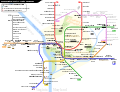
Map needed to be modified

Article(s): en:Washington Metro
- Request
- "–VT" should be added to the end of "Potomac Yard," with only the "VT" underlined, like in "Ballston–MU." The Yellow Line should also be cut back from "Greenbelt" to "Mount Vernon Square." OrdinaryJosh (talk) 00:09, 8 May 2023 (UTC)
- It might be better to put this on hold until May 19, when the Potomac Yard–VT station opens so that the work can be done in one fell swoop. OrdinaryJosh (talk) 04:49, 8 May 2023 (UTC)
- Graphist opinion(s)
![]() Request taken by Twotwofourtysix (talk), pending the May 19 date, as you wish. Twotwofourtysix (talk) 14:33, 15 May 2023 (UTC)
Request taken by Twotwofourtysix (talk), pending the May 19 date, as you wish. Twotwofourtysix (talk) 14:33, 15 May 2023 (UTC)
- @OrdinaryJosh: Done Twotwofourtysix (talk) 08:16, 19 May 2023 (UTC)
- Thank you so much! --OrdinaryJosh (talk) 12:22, 19 May 2023 (UTC)
- I already did the change along with few other minor adjustments. Unfortunately this SVG suffers a recent text-anchor bug and currently does not look right for some station labels. Sameboat - 同舟 (talk · contri.) 13:01, 19 May 2023 (UTC)
- Ah, gotcha. --OrdinaryJosh (talk) 13:05, 19 May 2023 (UTC)
- @Sameboat: Your version doesn't include the shortening of the Yellow Line to Mount Vernon Square, which is why I uploaded mine, even after you have added Potomac-VT Twotwofourtysix (talk) 13:13, 19 May 2023 (UTC)
- Sorry for the oversight. Just fixed it. Sameboat - 同舟 (talk · contri.) 13:25, 19 May 2023 (UTC)
- Thank you so much! --OrdinaryJosh (talk) 14:18, 19 May 2023 (UTC)
- Sorry for the oversight. Just fixed it. Sameboat - 同舟 (talk · contri.) 13:25, 19 May 2023 (UTC)
Historic Lincolnshire[edit]

Please can Lincolnshire be divided up into its three historic parts similar to how Yorkshire is shown in this image.

Please can two new images be created out of this image, one with Lincolnshire in its three parts but with no single red area highlighted and a second map (closer up) be created with the three areas numbered 1, 2 and 3


Article(s): Various
- Request
- I have a request for image one to be modified so that historic Lincolnshire is in its three parts as it’s not currently shown on the map in a way that is similar to how Yorkshire is currently shown and also a request for a two new SVG images of just historic Lincolnshire in its three parts with no highlighted areas and for one which is closer up with its three parts numbered so it’s three requests in total. MOTORAL1987 (talk) 08:58, 12 May 2023 (UTC)
- Graphist opinion(s)
Accession of the United Kingdom to CPTPP[edit]
Article(s): Accession of the United Kingdom to CPTPP or https://en.wikipedia.org/wiki/Accession_of_the_United_Kingdom_to_CPTPP if the link doesn't work
- Request
Highlight the United Kingdom in one solid colour, Highlight all crown dependencies and overseas territories in a lighter version of the colour used for the UK, Highlight Australia/Brunei/Canada/Chile/Japan/Malaysia/New Zealand/Peru/Singapore/Vietnam in another solid colour. Use a global map with the UK at the centre.
- Graphist opinion(s)

![]() Done @StevoLaker You didn't mention Mexico in your list, but I added it as I assume the intention was to include all CPTPP signatories. Used colors to match File:CPTPP Trade Agreement Map (Q4 2021).svg. Dragon401k (talk) 01:25, 15 May 2023 (UTC)
Done @StevoLaker You didn't mention Mexico in your list, but I added it as I assume the intention was to include all CPTPP signatories. Used colors to match File:CPTPP Trade Agreement Map (Q4 2021).svg. Dragon401k (talk) 01:25, 15 May 2023 (UTC)
- Thank you! This is exactly what i wanted StevoLaker (talk) 10:45, 15 May 2023 (UTC)
Blank map of Kampala[edit]

Current map of Kampala (OSM screenshot) on Commons

Article(s): (& other linguistic versions, especially
- Request
- Hi! I'd love to have a legible SVG map of Kampala with its main hills/districts and roads. My immediate use is to make a map of the (I'll try to do it on my own, but have never done this before, so maybe I'll call for help again for that specific overlay) but the map will be useful for anything related to the city. --Exilexi (talk) 09:29, 18 May 2023 (UTC)
- Reference material: https://www.researchgate.net/figure/Map-of-the-hills-of-Kampala-Mengo-including-the-boundaries-of-the-Kibuga-and-colonial_fig2_321723920 has the main hills of the city.
- Graphist opinion(s)
Puerto Rico[edit]
_(US50)_(-grid).svg/120px-Hawaii_in_United_States_(zoom)_(US50)_(-grid).svg.png)
Description of first image
_(US50)_(-grid).svg)
Article(s): Hawaiʻi on Wiktionary; A lot
- Request
- I suggest adding Puerto Rico to the United States, unless it's not part of the United States.
- Puerto Rico is part of the United States. People wonder why many Americans don't know it- well there's your answer. Just because "(US50)" appears in the title doesn't change how this image is actually used- see Hawaiʻi on Wiktionary. The caption there reads: "Hawaii in respect to the rest of the United States". You're giving people a stupid map that would need to be presented in a qualified way, and then that map is being used to imply that this is a map of the whole USA. You now get to choose whether WMF will continue to deceptively imply that Puerto Rico is somehow not part of the United States. Don't bring your decolonization ideological stuff at me when Russia still has Siberia and China has Tibet. As if! Yes Puerto Rico has got a special status. But they voted to become a state a few years ago (it wasn't accepted by the US Congress yet, this is just a fact that tends to discredit any "decolonization" ideological silliness). So Yes, it's the USA. Get off your high horse and show the people the full United States. --Geographyinitiative (talk) 22:26, 18 May 2023 (UTC)
- Graphist opinion(s)
Venezuela president recognition map[edit]

"Map showing the recognition of Juan Guaidó as acting president of Venezuela:"

.svg)
Article(s): en:Responses to the Venezuelan presidential crisis
- Request
- Hi! Users that are familiar with the topic know that the presidential crisis in Venezuela has been ongoing for four years, and it hasn't been until recently that it seemingly has come to an end. Naturally, this map: File:Venezuela president recognition map.svg has changed drastically since its beginning in 2019. To reflect these changes over the time, I've thought that an animated file, such as a gif, would be ideal. Are there contributors that could help with this? Many thanks in advance! --NoonIcarus (talk) 22:47, 12 January 2023 (UTC)
- I forgot to ask: if possible, an important aspect to include would naturally be the date where the current frame stands. Thanks again! --NoonIcarus (talk) 10:20, 15 January 2023 (UTC)
- Graphist opinion(s)
Copied from Video and Sound Workshop by 多多123 20:24, 21 May 2023 (UTC)